专业名称与代码:测绘工程 081201
专业培养目标:本专业培养具备国家基础测绘、工程测量、海洋测量、不动产测量、摄影测量与遥感、地理信息工程等测绘理论知识和能力,能在国家基础测绘、城市和工程建设、交通、资源勘探与开发、国土资源调查与管理、环境保护与灾害防治等领域从事测绘工程设计、实施、管理等方面工作的具有基础厚、素质高、能力强的测绘技术人才。
专业毕业要求
1.具有良好的人文社会科学知识和素养,包括思想道德素质、科学素质、人文素质、心理和身体素质,坚持社会主义核心价值观。
2.具有较强的语言表达和沟通能力,具有较强的团队协作意识。
3.思维活跃,具有开拓创新的意识。
4.具有扎实的数学、物理等自然科学和工程科学知识,以及基本的经济和管理知识,并了解当代科技发展的主要方面和应用前景。
5.具有扎实的测绘工程专业理论与技术知识。包括:测绘地理信息数据获取、处理、表达与利用的理论、方法与技术。
6.掌握各项测绘工程在规划设计、施工建设、竣工验收及运营管理阶段所进行的各种测量工作的理论方法与技术。
7.掌握测绘工程项目技术设计、施测、数据处理等方面的专业知识。
8.熟悉测绘法律、法规、行业技术标准与规范。
9.掌握计算机、互联网和信息技术在测绘工程中应用的技术与方法。
10.具有综合应用现代科技手段获取与处理信息的能力,有较好的专业文献阅读能力、工程科技报告和论文的写作能力。
11.具有较强的英语综合运用能力,能熟练阅读本专业的英文技术文献,并具有一定的英语口语交流能力。
12.具有较强的项目组织、管理与执行能力。
13.了解本学科基本的研究方法,具有运用所学知识发现、分析和解决测绘地理信息工程科技问题的能力,具备一定的独立思考和创新能力与较强的自学能力,能与时俱进地学习,适应未来发展的要求。
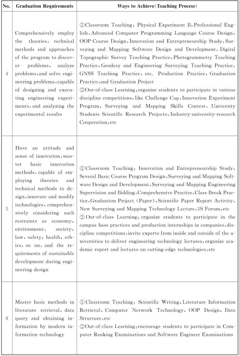
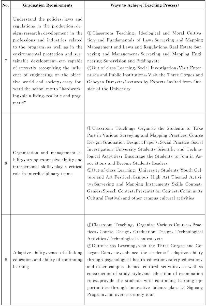
毕业要求及实现途径


主干学科:测绘科学与技术。
核心课程:测绘学概论、误差理论与测量平差基础、地图制图学基础、数字地形测量学、大地测量学基础、摄影测量学、GNSS原理及其应用、遥感原理与应用、地理信息系统原理、工程测量学、测绘软件设计与开发、变形观测与数据处理、工程地质学基础。
主要专业实验:水准仪、全站仪、GNSS接收机、数字摄影测量工作站、三维激光扫描仪等测绘仪器的操作;数字测图、GNSS、摄影测量、遥感、地图制图、地理信息系统测绘软件设计与开发。
主要实践性教学环节
1.计算机高级语言课程设计 1.5周
2.面向对象程序设计课程设计 1.5周
3.数字地形测量教学实习 5周
4.摄影测量教学实习 2周
5.大地测量教学实习 3周
6.GNSS教学实习 2周
7.工程测量教学实习 1周
8.毕业实习 10周
9.毕业设计 6周
修业年限:四年。
授予学位:工学学士。
相近专业:遥感科学与技术。
Program for Surveying and Mapping Engineering
Specialty and Code:Surveying and Mapping Engineering 081201
Education 0bjective:The program objective is to instruct students'basic theory,basic knowledge and skills in national basic surveying and mapping,engineering surveying,marine surveying,real estate surveying,photogrammetry and remote sensing,geographic information engineering,etc.and to develop students to be surveying and mapping professionals with solid foundation of knowledge,high quality and strong capability working in the fields of national basic surveying and mapping,urban and engineering construction,communications,exploitation and development of resources,land and resources investigation and management,environmental protection and disaster prevention and control,etc.
Graduation Requirements
1.Have good humanistic and social science knowledge and accomplishment,including ideological and ethical standards,scientific qualities,humanistic qualities,psychological and physical qualities,adhering to the socialist core values.
2.Have strong expressive and communication ability and strong teamwork spirit.
3.Think actively and have pioneering and innovative spirit.
4.Master the solid knowledge in natural science and engineering science such as mathematics, physics and basic economic and management knowledge,have a good understanding of the major areas and application prospect in the contemporary scientific and technological development.
5.Master the solid theoretic and technical knowledge of surveying and mapping engineering,including theories,methods and technologies for data collection,processing,expression and application of surveying and mapping geographic information.
6.Master the theories,methods,and techniques in various surveying and mapping projects during the planning design,construction,completion approval and operations.
7.Master the technical knowledge in technical design,working,and data processing in the surveying and mapping engineering projects.
8.Be familiar with the laws,regulations,and industrial technical standards and codes of surveying and mapping engineering.
9.Master the technologies and application methods of the computer,Internet and information technology in surveying and mapping engineering projects.
10.Have comprehensive capability in applying modern technologies to obtain and process information;have good abilities in reading professional literature and writing engineering technology reports and papers.
11.Have a strong comprehensive ability in English:read English technical literature fluently and have a satisfactory English speaking ability.
12.Have strong capability in project organization,management and execution.
13.Understand the basic research methods,apply the learnt knowledge to discovering,analyzing and solving the engineering problems about surveying and mapping geographic information,have independent thinking,innovative ability and strong self-learning ability,learn knowledge by keeping pace with the times so as to adapt to the requirements of the future development.
Graduation Requirements and Ways to Achieve


Major Disciplines:Surveying and Mapping Science and Technology.
Main Courses:Introduction to Geomatics,Error Theory and Foundation of Surveying Adjustment,Foundation of Cartography,Digital Topography,Foundation of Geodesy,Photogrammetry,Principles and Applications of GNSS,Remote Principles and Applications of Sensing,Geographic Information Principles of System,Engineering Surveying,Surveying and Mapping Software Design and Development,Deformation Observation and Data Processing,Introduction to Engineering Geology.
Lab Experiments:Operation of surveying and mapping instruments,including level gage,total station,GNSS receiver,digital photogrammetric station,3D laser scanner,etc,modern survey data processing skills for digital mapping,GNSS,photogrammetry,remote sensing,map making,and geographic information system,surveying and mapping software design and development.
Practical Work
1.Advanced Computer Programming Language Course Design 1.5 Week
2.Object-oriented Programming Course Design 1.5 Week
3.Digital Topographic Survey Teaching Practice 5 Weeks
4.Photogrammetry Teaching Practice 2 Weeks
5.Geodetic Surveying Teaching Practice 3 Weeks
6.GNSS Teaching Practice 2 Weeks
7.Engineering Surveying Teaching Practice 1 Week
8.Graduation Practice 10 Weeks
9.Graduation Project 6 Weeks
Duration:four years.
Degree Granted:Bachelor of Engineering.
Related Specialties:Remote Science and Technology of Sensing.
测绘工程专业课程教学计划表
Course Descriptions of Surveying and Mapping Engineering测绘工程专业课程分类统计


注:1.通识教育选修课学分和创新创业自主学习学分未列入具体学期。通识教育选修课建议涵盖经济管理等知识。
2.专业选修课学分不得低于17学分,建议选修课内容涵盖:土力学B、计算机图形学,土木工程概论、岩土工程监测、测绘管理与法律法规、不动产测量与管理、测绘工程监理与招投标、文献信息检索、科技论文写作等知识。
Course Category Statistics of Surveying and Mapping Engineering

免责声明:以上内容源自网络,版权归原作者所有,如有侵犯您的原创版权请告知,我们将尽快删除相关内容。


