专业名称与代码:信息工程 080706
专业培养目标:本专业以空间信息科学为基础,以信息获取、信息的表达与存储、信息传输、信息网络技术、信息管理、分析为核心建立专业知识结构。培养具有信息开发、处理和应用,以及信息系统设计的专业知识,具备基于3S技术(GIS技术、GNSS技术、RS技术)、移动技术、通信网络等技术为基础的空间信息工程、空间信息服务、空间信息平台和空间信息系统集成技术的高级工程技术人才。
培养能在信息产业等相关部门从事信息化软件、新信息服务业务的设计、研发、信息网络集成以及应用等方面工作的信息工程学科的高级工程技术人才,同时也能从事空间信息领域、计算机软件和通信网络领域的专业技术工作;本专业强调与应用领域的密切结合,强调与国内大型企业联合培养新型的人才,强调按企事业单位的具体要求,定制企业所需的开发人才。在培养的课程体系设置方面,主要体现先进性、灵活性、复合性、工程性。
专业毕业要求
1.掌握扎实的数学基础理论和良好的外语技能,掌握文献检索的基本方法,学习空间信息科学与技术的基本理论和基本知识。
2.掌握空间信息系统的采集、开发、分析、处理及应用的技术与方法。
3.具备分析、设计、开发、测试、维护具有GIS、GNSS、RS技术特征的空间信息网络软件的实际工作能力,满足相关行业企业需求。
4.熟悉互联网络的协议和空间信息领域里的方针、政策和法规。
5.了解互联网络和空间信息领域里的理论前沿、应用前景、发展动态、行业需求。
6.具备独立获取知识、提出问题、分析问题和解决问题的基本能力,具有一定的科学研究和实际工作能力。满足升学和学术机构需求。
毕业要求及实现途径


主干学科:0812计算机科学与技术、0816测绘科学与技术。
专业核心课程:地理信息系统原理、嵌入式操作系统、空间信息服务系统设计、互联网、软件开发、信息网络系统、GNSS原理及其应用、计算机结构与组成、遥感原理与应用、算法设计与分析、数字信号处理B。
主要专业实验:地理信息系统原理,互联网软件开发,GNSS原理及其应用,计算机结构与组成,计算机图形学A,算法设计与分析、数字信号处理B。
主要实践性教学环节:计算机高级语言课程设计、面向对象程序设计课程设计、数据结构课程设计、数据库课程设计、地理信息系统实习、智能终端软件开发实习、信息网络开发综合实习、导航与定位技术实习、毕业设计。
修业年限:四年。
授予学位:工学学士。
相近专业:计算机科学与技术、软件工程。
Program for Information Engineering
Specialty and Code:Information Engineering 080706
Education 0bjective:This major is on the basis of spatial information science.Its professional knowledge structure is established with information retrieval,information presentation and storage,information transmission,information network technology,information management and analysis as the core.We train high quality engineers who will be provided with professional knowledge in fields like information development,processing and application,information system design,spatial information engineering,spatial information service,spatial information platform,spatial information system integration technology that based on 3S(GIS,GNSS,RS)technologies,mobile technology and communications network.
We cultivate senior technical personnel of information or related industries,who will be engaged in the fields of information software,new information service business design,research and development,information networks integration and applications.Meanwhile,they will be competent for other professional technical work,such as spatial information science,computer software and communication network area.
This major emphasizes a strong connection with application fields,which results in the combination with large national firms of training the new breed of talents.Also,we tailor our students to meet with the requirements of enterprises and public institutions.In the setting of course systems,we focus on qualities of advancement,flexibility,compositionality and engineering quality.
Graduation Requirements
1.Have a good command of mathematics and English kills,master the basic approaches in literature retrieval,and learn the fundamental theories and knowledge of spatial information science and technology.
2.Have a good command of the technologies and methods of collection,development,analyzing processing and application in spatial information system.
3.Have the practical work ability on analysing,designing,developing,testing and maintaining a spatial information network software which have technical features of GIS,GNSS and RS.Meet the requirements of related industries.
4.Be familiar with the network protocols and the policies,strategies and rules in the field of spatial information.
5.Understand the frontier theories,application prospect,development trends,industry needs in the field of Network and Spatial Information.
6.Have the basic skills of obtaining knowledge,questioning,problem analysis and problem solving.Have a certain capacity for scientific research and practical work.Meet the requirements of academic or higher education institutions.
7.Innovation and entrepreneurial ability.
Graduation Requirements and Ways to Achieve


Major Disciplines:Computer Science and Technology,Science and Technology of Surveying and Mapping.
Main Courses:The Principles of Geographic Information System,Embedded Operating System, Design Principle of Spatial Information Service System,Internet Software Design,Information Network System,Principles and Applications of GNSS,Computer Structure and Composing,Principles and Applications of Remote Sensing,Algorithms Design and Analysis,Digital Signal Processing B.
Lab Experiments:The Principles of Geographic Information System,Internet Software Design, Principles and Applications of GNSS,Structure and Composing,Computer Graphics A,Algorithms Design and Analysis,Digital Signal Processing B.
Practical Work:Course Design for Computer High-Level Language C++,Course Design of Object-Oriented Programming,Course Design for Data Structure A,Course Design for Database,Geographic Information System Practice,Intelligence Terminal Software Development Practice,Information Network Design Comprehensive Practice,Navigation and Orientation Practice,Graduation Design (Thesis).
Duration:four years.
Degree Granted:Bachelor of Engineering.
Related Specialties:Computer Science and Technology,Software Engineering.
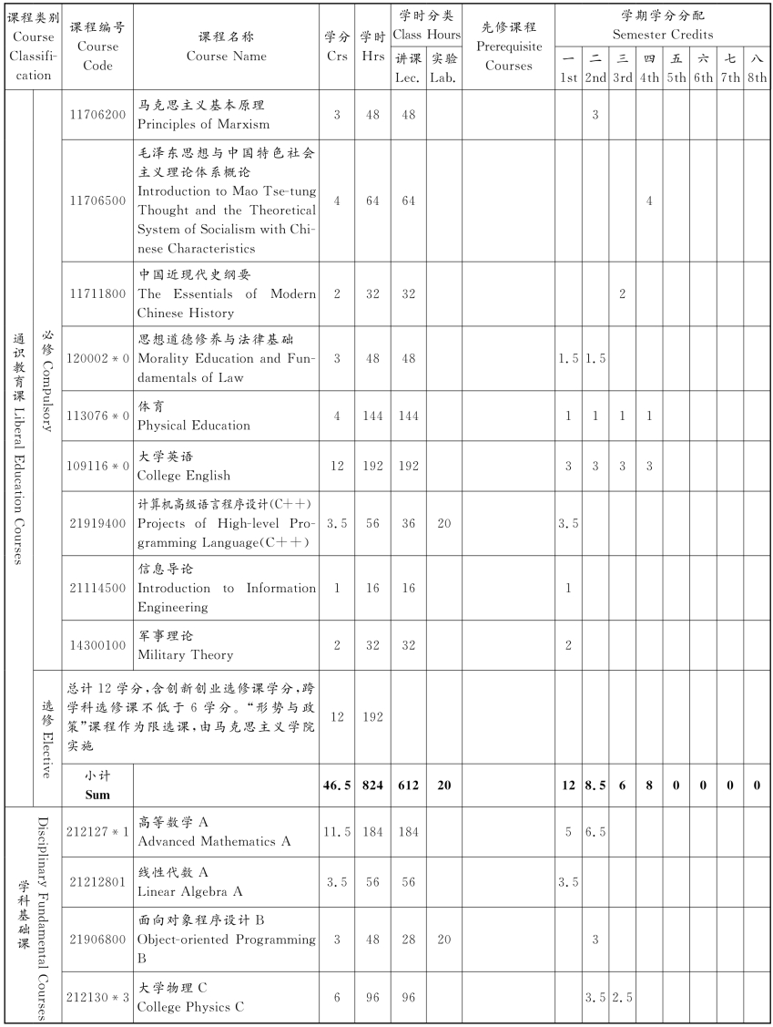
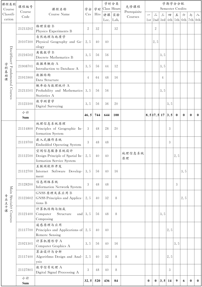
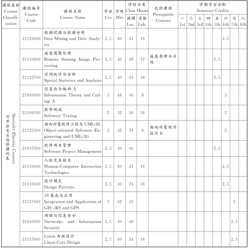
信息工程专业课程教学计划表
Course Descriptions of Information Engineering


注:通识教育选修课学分和创新创业自主学习学分未列入具体学期。
信息工程专业课程分类统计
Course Category Statistics of Information Engineering

免责声明:以上内容源自网络,版权归原作者所有,如有侵犯您的原创版权请告知,我们将尽快删除相关内容。


