专业培养目标
1.培养具备良好的综合素质和职业道德。
2.掌握遥感科学、测绘科学、地理信息科学基础理论、知识和技能。
3.结合计算机科学与技术在国土资源、城市规划、水利、电力、地质工程、环境监测、海洋勘查、国防等领域从事空间信息获取、处理、管理与应用的专门高级技术人才。
专业毕业要求
具备扎实的数理与外语基础,牢固掌握计算机理论和技术,系统学习遥感科学、测绘科学和地理信息科学的理论及知识,并接受系统开发技能和应用方法训练,能结合计算机技术、地理信息技术分析解决遥感及测绘科学研究与应用中实际问题,并具备从事空间信息相关领域科学研究和工程开发等方面的能力。
1.具备良好的综合素质,包括思想道德修养、科学素质、人文素质、心理和身体素质,坚持社会主义核心价值观;具有良好的职业道德与修养,具备法律法规意识。
2.具备扎实的数理与外语基础,具有从事工程与科研所需的相关自然科学知识以及一定的经济管理知识。
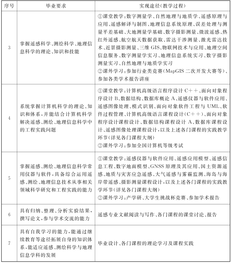
3.系统掌握遥感科学、测绘科学、地理信息科学的理论、知识和技能。
4.系统掌握计算机科学的理论、知识和体系,并能结合计算机科学解决遥感、测绘、地理信息科学中的工程与科研问题。
5.掌握遥感、测绘、地理信息科学常用仪器与软件,具备综合运用遥感、测绘、地理信息技术从事相关领域科学研究和工程实践的能力。
6.具有归纳、整理、分析实验结果,撰写论文,参与学术交流的能力。
7.具有自我学习的能力,能通过继续教育等途径拓展自身的知识体系,能适应遥感、测绘科学与地理信息学科的发展。
毕业要求及实现途径

主干学科:测绘科学与技术、计算机科学与技术、地理学。
核心课程:数字测量学、自然地理与地质学、遥感原理与应用、地理信息系统原理、遥感图像处理、遥感信息工程、数字摄影测量、微波遥感、遥感应用模型、数字地面模型。
主要实践性教学环节:计算机高级语言课程设计(C++)、面向对象程序设计课程设计、自然地理与地质学实习、数字测量学实习、数据库课程设计、数据结构课程设计、地理信息系统实习B、遥感图像处理课程设计、数字摄影测量实习、毕业设计。
修业年限:四年。
授予学位:工学学士。
相近专业:测绘工程。
Program for Remote Sensing Science and Technology
Specialty and Code:Remote Sensing Science and Technology 081202
Education 0bjective
1.The goal of the Undergraduate Program of RS Science and Technology is to develop them with comprehensive quality and excellent professional ethics.
2.To make them master the basic theory,knowledge and skills of Remote Sensing Science,Surveying and Mapping and Geographic Information.
3.They should be able to apply computer science and technology in the fields of land resource,urban planning,hydraulic engineering,electrical power engineering,geological project,environmental monitoring,and ocean investigation,national defense,and so on,to acquire,process and analyze the information of remote sensing.It is aimed at cultivating professionally high-level technical talents of related spatial information engineering application.
Graduation Requirements
After mastering the fundamentals of mathematics,physics and foreign language,the students will master computation science and technology fully,and study remote sensing science,survey and mapping science,the geographic information system computer science systemically.They will be trained to master how to develop system and application method.So,they will be able to do research work and engineering development.
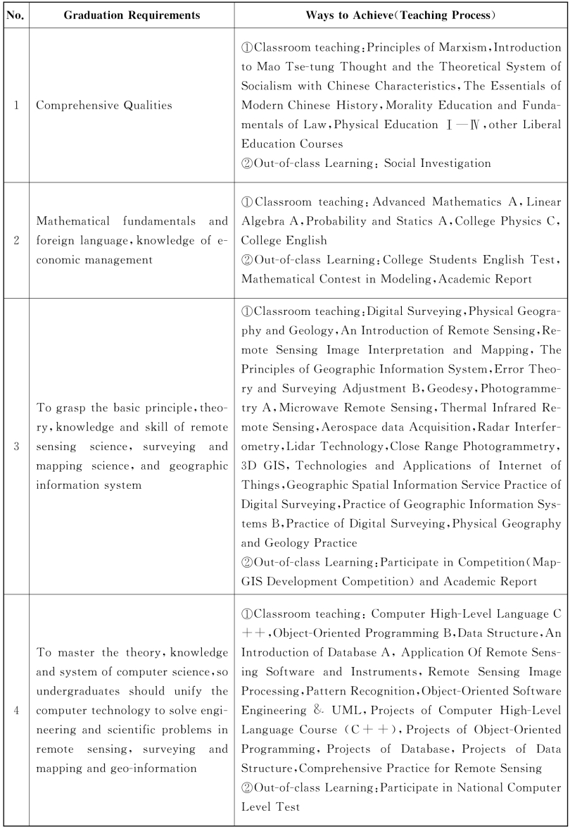
1.To obtain comprehensive quality,including ideological and moral cultivation,scientific quality, cultural quality,psychological and physical quality,and adhere to the socialist core values.Have good professional ethics and self-cultivation,and awareness of laws and regulations.
2.To be qualified with solid mathematical foundation and foreign language.To master natural science knowledge and knowledge of economic management,both are required for the engineering and scientific research.
3.To grasp the basic principle,theory,knowledge and skill of remote sensing science,surveying and mapping science,and geographic information system.
4.To master the theory,knowledge and system of computer science,so undergraduates should unify the computer technology to solve engineering and scientific problems in remote sensing,surveying and mapping and geo-information.
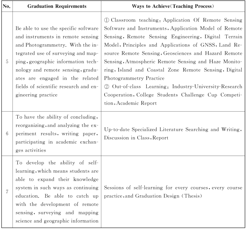
5.To be able to use the specific software and instruments in remote sensing and photogrammetry.With the integrated use of surveying and mapping,geographic information technology and remote sensing,graduates are engaged in the related fields of scientific research and engineering practice.
6.To have the ability of concluding,reorganizing,and analyzing the experiment results,writing paper,and participating in academic exchanges activities.
7.To develop the ability of self-learning,which means students are able to expand their knowledge system in such ways as continuing education.Be able to catch up with the development of remote sensing,surveying and mapping and geo-information.
Graduation Requirements and Ways to Achieve
Major Disciplines:Surveying and Mapping,Computer Science and Technology,Geography.
Main Courses:Digital Surveying,Physical Geology and Geomorphology,Remote Sensing Principles and Applying,The Principles of GIS,Digital Remote Sensing Image Processing,Remote Sensing Engineering Digital,Photogrammetry,Microwave Remote sensing,Application Model of Remote sensing,Digital Terrain Model,etc.
Practical Work:Advanced Programming Language(C++),Projects of Object-Oriented Programming,Projects of Data Structure A,Projects of Database,Practice of Geographic Information Systems B,Practice of Digital Surveying,Practice of Digital Photogrammetry,Practice of Physical Geography and Geology,Projects of Remote Sensing Image Processing,Comprehensive Practice of Remote Sensing,Graduation Design(Thesis).
Duration:four years.
Degree Granted:Bachelor of Engineering.
Related Specialties:Surveying Engineering.
遥感科学与技术专业课程教学计划表
Course Descriptions of RSScience and Technology
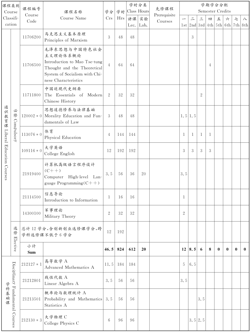
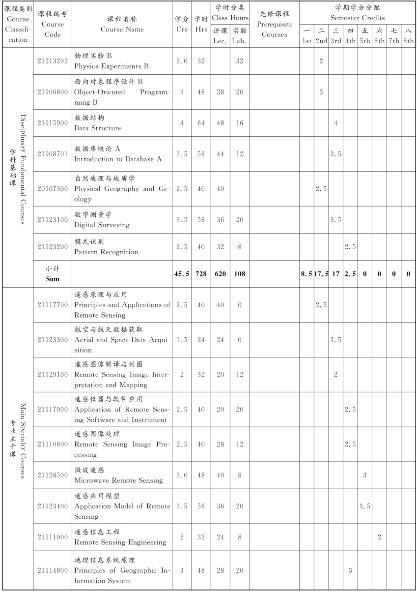

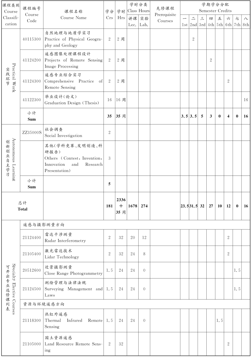
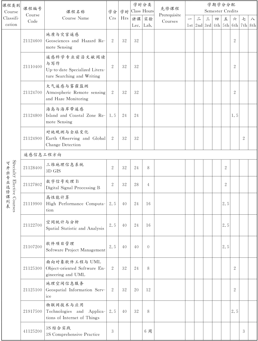
注:1.通识教育选修课学分,专业选修课学分以及创新创业自主学习学分未列入具体学期。
2.“3S综合实践”为第七学期的专业综合实践选修课程,由教师开展遥感科学与技术领域的综合实践能力教学。开课时间为6周(3学分),具体由教师带领学生针对本专业开展综合应用与开发。
遥感科学与技术专业课程分类统计
Course Category Statistics of RSScience and Technology

免责声明:以上内容源自网络,版权归原作者所有,如有侵犯您的原创版权请告知,我们将尽快删除相关内容。


